Pawton Quoit is a magnificent portal dolmen built by Cornwall’s stone age inhabitants. The imposing megalith sits, mostly intact, atop a ridge overlooking a steep valley.
Also known as Giant’s Quoit, the monument is found along the back lanes of Wadebridge, up a private farm track. The enormous capstone, which juts out incongruously against the landscape, must weigh at least 15 tonne, and perches on just three points of the supporting upright stones. Part of it has sheared off, and sits where it fell in front of the quoit’s façade. The dolmen sits on a raised earthen mound, perhaps the vestiges of a cairn that covered some or all of the monument.
In Cornwall we call dolmen quoits. A reference to the folk belief that Cornwall’s many megaliths were created by giants throwing stones at each other – quoit being a reference to the dolmen capstones resembling the discs thrown in a traditional game of quoits.
Cornwall’s quoits are thought to have been built in the early to mid-neolithic period. We can only wonder at the engineering skill, and size of the labour force required, to accomplish such a feat in the stone age. The society that built the quoit would have been organised, and have enough abundance to spare those workers from the business of farming food. Moving the huge capstone up the hill, and placing it on top of the uprights, would have been an extraordinary feat. The enormous size of it would have been impractical, and much larger than required to cap the chamber – it’s a statement.
The accomplishment of an immense engineering project like Pawton Quoit must have inferred status upon the community responsible. Portal dolmens would have been visually impressive, dominant markers in the landscape, looking over neolithic settlements and fields. Cornwall would have been mostly covered in dense temperate rain forest, except for small areas cleared for farming and settlement. Hilltops, like this one, would have been beacons rising out of the humid, wild tangle of forest, serving as places of safety and gathering.
Part of the capstone has sheared off and sits in front of the dolmen’s facade
In Cornwall quoits are often found overlooking valleys with a water source, or in places where neolithic settlements and fields have been found. These first farmers transformed the landscape for agriculture and permanent settlements. They were also the first megalithic builders, modifying their environment with monuments like Pawton.
Looking inside the quoit
The day of my visit the weather is wild, we are lashed by a squall of wind and rain blowing in off the North coast. In the early Neolithic period, the climate would have been warmer and drier than it is today. The hilltops, ridges and tor summits would have been more hospitable to settlement before the climate changed in the early bronze-age.
The original purpose of portal dolmen is unknown. It’s possible they were territorial, or used for burial and funerary rites. Although little human remains have been found, suggesting their primary purpose was something else. Given how architecturally impressive quoits like Pawton are, it seems they were meant to be seen. Were these marvels of prehistoric engineering built to meet the needs of the living, rather than those of the dead.
Lichen on the capstoneThe stones host an assortment of lichen
They could be cathedrals of spiritual significance, marking places considered sacred. Possibly for capturing earth energies, or marking the seasons through solar and astral alignments. Maybe the quoits were built to bring people together in ways we can’t imagine in our modern world that’s so disconnected from nature. Maybe these monuments were built for worshipping gods that have long been forgotten.
Or maybe, just maybe, the Cornish giants were real.
From Popular Romances of the West of England . Robert Hunt, 1865
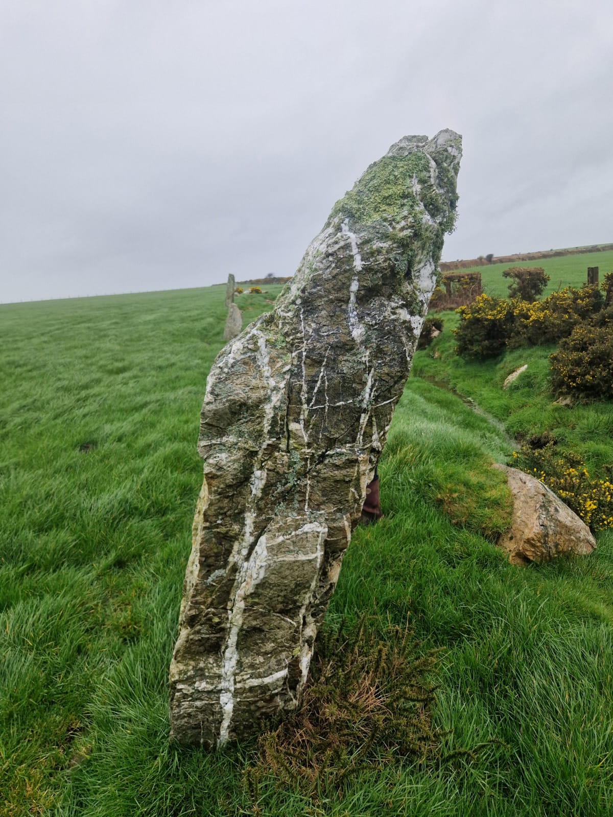
The Nine Maidens stone row stands in a field immediately south of the A39. The early bronze-age monument sits in a field on Breock Downs between St Columb Major and Wadebridge. Nine irregular arrow shaped menhirs stand in a row running SW to NE, parallel to a small stream whose banks are littered with what appear to be large field clearance stones.
Standing from 0.8 metres to 1.9 metres tall, with one recumbent stone 3 metres in length, the menhirs are local grey slate rich with thick quartz veins weaving elaborate paths across them. They are living breathing stones hosting their own eco system of mosses and rare lichens.
To access the stone row, you pass a sleeping hawthorn tree looming over a pool of water. The lone hawthorn is known in Celtic mythology as a fairy tree, a gateway between worlds, a marker of ancient boundaries and sacred ground. It would seem to those early bronze-age people that this ground was indeed sacred. To the North-East of the row there is a solitary menhir, now fallen and broken up, known as The Fiddler, or Magi Stone, which stood on the same alignment as the maidens. The monolith and the stone row are possible ceremonial parts of a bronze-age complex of sites, leading to the burial barrows on the highest point of the ridge.
Views from the barrows on the hilltop north of the Nine Maidens
Standing on top of the largest barrow, to the south I can see the iron-age hill-castles of Castle an Dinas and Demelza Castle, to the east the highest points on Bodmin Moor, Rough Tor and Bronn Wennili (Brown Willy) are visible. Looking to the north I can see Padstow Bay, and north-west along the coast to Trevose Head, the site of an iron-age cliff-castle and a headland that has given up numerous bronze-age finds. Territorially this hillside would have been an important location.
The fields and hedgerows surrounding the monument are littered with large stones, similar to those used in the stone row. Most of these are a result of field clearances, but some look suspiciously similar in shape and size to the stone row menhirs, with thick quartz veins. I can’t help but wonder if there were more stones to this row, or if it’s possible there were other stone monuments in the complex.
Richard Carew in his Survey of Cornwall (1602), names the site TheSisters, and John Norden, in 1728, mentioned another adjoining site he called the Nine Sisters, which may have been a double stone row or circle. In 1995 a team of dowsers believe they found 4 more stones to the row and a second stone row 25ft to the west of it. (Cheryl Straffon, 2004.)
Breock Downs itself is home to other significant prehistoric monuments, including the neolithic dolmen Pawton Quoit, and Men Gurta the largest monolith in Cornwall. It seems reasonable to assume that this was a culturally significant area of ancient Cornwall, a landscape rich with meaning. Were the Nine Maidens a processional monument leading to the peak of the hill where the prominent burial barrows sit. Was this spot a node in a network of hills, ridges and beacons across the spine of mid-Cornwall.
The Nine Maidens will no doubt continue to keep their secrets close, and give us only questions, but it’s the mystery of these Cornish megaliths that has captured imaginations for millennia after millennia.
I board the Looe valley line, the two fuggy carriages stuffed with hot, pink skinned tourists. All headed for a bucket and spade day at the seaside.
My stop, the Cornish hamlet of Causeland, comes into view through the trees of the wooded valley, as the train snakes slowly down the scenic branch line. My destination, one of Cornwall’s most magnificent megalithic monuments.
Duloe stone circle is thought to date from the early to middle bronze age – approximately 4000 years ago – around 2000 years BCE. Like all Kernow’s megalithic monuments, it is still an alluring enigma and sits just three miles from Causeland station.
The train stops here so rarely I must specifically request it with the conductor, who instructs me to ‘wave the driver down’ upon my return.
With relief I jump off into the fresh air alone. There is a little scrap of platform, with a small concrete shelter. The burbling stream runs alongside, a remnant of the 18th century Looe to Liskeard canal.
Once the train is out of earshot, I find myself in a timeless scene. The fields behind the stream are alight with riotous swathes of fuchsia fireweed. I’m alone with a chorus of birds, whistling and chattering, accompanied by a band of bees, drunk on the wildflowers. There is something magical about having a place to myself. I feel like I’ve stepped through the looking glass to another realm. My own secret garden.
I dally up a narrow lane, lined by old Cornish hedgerows, full of early – summer life. In the cool dappled shade, hogweed dances among the pink campion flowers. Ferns droop and fight with bindweed for space. Foxglove spines set seed, their flowers now just a memory of spring.
I find the path I identified on the map, starting in the valley, rising out of a carpet of meadowsweet
I make my way to a clearing atop the hill between two deep valleys of woodland. Butterflies flit among the drooping grass seed. Taking in the view I can see how this was an important vantage point in ancient times. The hill-tops of Bodmin moor to the North – adorned with the remains of prehistoric societies, the Cornish coast to the south.
I know this is the ridge-top the stone circle sits upon.
Consulting my map, I choose to rebel against the prescribed right of way. I want to travel as the crow flies, to truly familiarise myself with the landscape the ancient monument belongs to. To travel across country on pilgrimage to a sacred space, like I imagine the bronze-age peoples once did. I have purposefully taken the overland route from the train-stop, avoiding the road, to avoid the trappings of modernity.
I trespass, keeping to the borders of fields. Scrambling over hedgerows, following badger tracks, ducking through barbwire.
I track boot prints into a maize field. Others have been this way. At this point I can hear the stones calling – my internal GPS pulling me.
My breath catches as through the hedgerow I glimpse my first sight of the menhirs. I push through the ivy, over the stone wall, into the neighbouring field.
The stone circle stands in the North end. The grass a sea of standing hay, peppered with hogweed, white flowers bobbing in the breeze. Spires of thistle, adorned with purple crowns. Russet docks, heavy with seed, whisper in the breeze.
Swathes of drooping nettles border the field, heavy, bowing under the weight of their seeds. Brown butterflies flit amongst them.
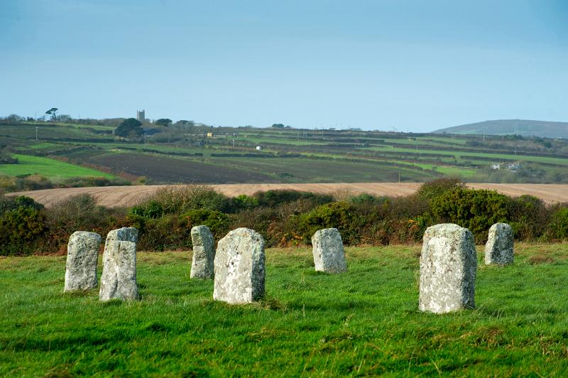
I approach the ring of eight granite, weathered monoliths with a tingle in my sternum. Thick with seams of pearly quartz, dressed in patches of hairy lichens and velvet moss. Hues of pink and grey run through the white rock. The tallest menhir reaches a metre above my head, the smallest shoulder height. Despite being the smallest stone circle in Cornwall, it boasts the grandest, largest stones.
I step into the monument barefoot, the energy palpable, a visceral reaction in my solar plexus. A distinctly feminine energy. I admire the stones, running my fingers over them, exploring like a familiar lover. Enjoying the smoothness of the quartz juxtapositioned with the coarseness of the darker granite.
A feeling of wellbeing, a wave of tingles, like blood returning to a limb, floods my being. My feet connect with the earth energy. I ground myself, taking root in the centre.
Temporally dislocated, I sink back through the millennia.
Cornwall Live
No doubt the monument had many uses over the millennia, for gatherings, ceremonies, healing and connecting with the spirits of the land. The discovery of a bronze age burial urn inside the circle, supposedly containing cremated human bones, suggests to some a burial site – with the circle possibly built around a cairn.
The four largest stones are set at the cardinal points of North, East, South and West. There is also a potential alignment with late neolithic and bronze age monuments on Bodmin moor to the North. To me this suggests a higher purpose, spiritual work connecting with earth energies and reaching altered states of consciousness. (This is based purely on gut feeling rather than anything resembling archaeological evidence.) It’s possible the urn was buried at this site because of its prior significance.
I imagine how the white quartz menhirs would have shone beatific by day and glowed celestial in the full moon light. A sacred site drawing pilgrims from across bronze age Britain. The hardships and perils they would have faced upon their journey. Called by this stone monument, set high upon the hill rising between the valleys of thick temperate rainforest. Today it continues to be a treasure, a place of worship, for communing with nature and the ancestors. Frequented by megalith enthusiasts, dowsers, geomancers, pagan worshippers, spiritual pilgrims and local dog walkers.
Representing different meanings to different people throughout time. Today, after four millennia it stands as a third space, a refuge, a place of healing and regeneration.
After spending some time with the individual stones, I take myself to the centre to sit and meditate. I sink back to lie upon the welcoming grass. Feeling the breath of the mild breeze upon my face, it wicks the sweat from my brow. The only sound the birdsong and the faint melody of children playing somewhere in the village. The peace is obtrusively broken by the sound of a strimmer starting up in the distant far corner of the large field. I mentally will him to stop and he veers off and takes his strimmer elsewhere. Perhaps subconsciously aware he is not welcome.
Looking up at the wisps of cloud that float across the azure sky I feel a profound sense of connection between heaven and earth.
I close my eyes and start my breathing into my meditation. Calling upon the elemental spirits of the earth below, the air above, the water of the blind springs that I suspect flow deep underneath the impermeable granite rock, and the fire of life that animates us all.
As I lay in the centre, two women arrive at the circle with a curious dog who comes to lie alongside me. As I visualise the healing light rising from the earth, transmitted via the stones the dog reacts, barking until I reach out and place a hand upon him. He settles and continues to lie beside me until I finish my meditation. The owner apologises, but there is no need. I often find dogs are sensitive to the energies that lie within these megalithic monuments.
Today’s profound experience has left a deep imprint upon me. Pleasantly exhausted I opt for the beaten path back to Causeland train station. I venture through the village and descend back into the valley via an endless hot dusty lane. I reach the cool lushness of the flora rich valley with relief and take my place on the platform to await the train back to Liskeard. I hear the old diesel engine chugging through the trees and, as instructed, wave the driver down.
First published in Northern Earth Magazine: Issue 182
Cover Image: Merry maidens, Penwith. From photoeverywhere.co.uk
The Merry Maidens, one of Penwith’s four remaining stone circles, are a fine example of a Cornish megalithic monument. A perfect seventy-eight-foot circle, consisting of nineteen granite stones of around four foot in height.
Once named ‘Dans Maen’ – ‘Dance of Stones’ in Cornish, this is a probable reference to the monument’s adulterated Christian origin myth – maidens turned to stone for dancing on the Sabbath.
Often coined as ‘The Cathedrals of the Prehistoric,’ I find stone-circles the most atmospheric and magical of all megalithic sites. The most accepted dating for these monuments is from the early bronze age – 2500 – 1600 BC, although due to a lack of archaeological evidence they remain an enigma of prehistoric society.
Could they be calendars of stone, wheels of time marking nature’s cycles, following celestial movements, harmonising with earth and cosmos. Or spaces for gatherings, festivals and rites of passage.
There are thought to have been around ten other stone circles in the Penwith district of Cornwall, most now lost or destroyed. The Merry Maidens monument itself had a twin circle, a few hundred metres to the east, also sadly destroyed by farmers.
The high quartz content of these granite menhirs could explain some of the unusual sensations, such as electric shocks reported by visitors to the monument, for quartz is known for its piezo-electric effect.
Sitting upon the North-facing slope of a hill, above a wooded valley, you can see the notable prehistoric sites of Chapel Carn Brea and Sancreed Beacon from the circle (Carn Galva on the north coast can be seen on a clear day,) suggesting its significance in the landscape.
This megalith was once part of a greater complex of bronze-age sites. Within half a mile stand the epic twin menhirs The Pipers, as well as four other bronze-age standing-stones, barrows and even a neolithic cairn. Maybe these sites are key nodes in a network of megalithic monuments which turned the wider landscape into a charged space.
Some megalith pilgrims have reported peculiar goings on at the Merry Maidens, such anomalous lights and strange disembodied voices.
Large magnetic variations have been recorded, unusual electromagnetic phenomena that has been known to deflect compass readings. The stones themselves are flattened on the inside and curved on the outside of the circle, which could suggest the possibility that the circle itself acted as some kind of resonator or amplifier.
These are all curious theories that fire the imagination.
The neolithic inhabitants of this land were the first to make their mark, the first to adorn and shape the landscape to their liking. Here in the southern half of the Penwith district this process seems to have started with Tregiffian barrow (the chambered cairn that sits just south of the Merry Maidens) and continued through the latter half of the bronze-age, with standing menhirs, holed stones and of course the stone circles.
In the wooded valley below, in Boleigh, there is evidence of an iron-age settlement and a fine intact example of the uniquely Cornish iron-age fogou.
Is it possible the Merry Maidens were the crowning glory of a sacred landscape revered over millennia?